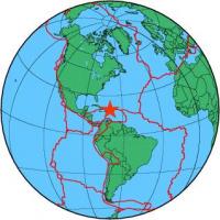
| Magnitude | 4.3 |
| Region | DOMINICAN REPUBLIC REGION |
| Date time | 2012-10-21 15:07:31.0 UTC |
| Location | 19.521 ; -69.824 |
| Depth | 18 km |
| Distance | 51 km NE of San Francisco de Macorís, Dominican Republic / pop: 124,000 / local time: 11:07:31.0 2012-10-21 16 km N of Nagua, Dominican Republic / pop: 33,800 / local time: 11:07:31.0 2012-10-21 |
All data providers for this event:
GeoForschungsZentrum (GFZ) -- Potsdam, Germany (GFZ)National Earthquake Information Center, U.S. Geological Survey -- Golden, United States (NEIC)
Further information can be found at:
Universidad Autonoma de Santo Domingo -- Santo Domingo, Dominican Republic (UASD)GeoForschungsZentrum (GFZ) -- Potsdam, Germany (GFZ)
National Earthquake Information Center, U.S. Geological Survey -- Golden, United States (NEIC)