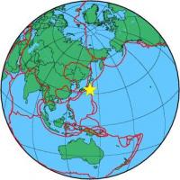
| Magnitude | 4.5 |
| Region | OFF EAST COAST OF HONSHU, JAPAN |
| Date time | 2012-12-12 06:41:07.1 UTC |
| Location | 33.854 ; 141.296 |
| Depth | 60 km |
| Distance | 211 km SE of Kisarazu, Japan / pop: 122,000 / local time: 15:41:07.1 2012-12-12 176 km SE of Kamogawa, Japan / pop: 29,100 / local time: 15:41:07.1 2012-12-12 |
All data providers for this event:
GeoForschungsZentrum (GFZ) -- Potsdam, Germany (GFZ)Geophysical Survey of the Russian Academy of Sciences -- Obninsk, Russia (GSRAS)
National Earthquake Information Center, U.S. Geological Survey -- Golden, United States (NEIC)
Further information can be found at:
National Earthquake Information Center, U.S. Geological Survey -- Golden, United States (NEIC)Japan Meteorological Agency Seismic Network -- Tokyo, Japan (JMA)
GeoForschungsZentrum (GFZ) -- Potsdam, Germany (GFZ)