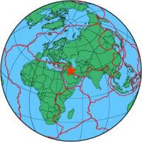
| Magnitude | 4.4 |
| Region | IRAN-IRAQ BORDER REGION |
| Date time | 2012-03-10 21:41:07.0 UTC |
| Location | 32.535 ; 46.995 |
| Depth | 10 km |
| Distance | 79 km NNW of Al ‘Amārah, Iraq / pop: 323,000 / local time: 00:41:07.0 2012-03-11 31 km SW of Dehlorān, Iran / pop: 46,000 / local time: 01:11:07.0 2012-03-11 |
All data providers for this event:
GeoForschungsZentrum (GFZ) -- Potsdam, Germany (GFZ)International Institute for Earthquake Engineering and Seismology -- Tehran, Iran (IIEES)
Geophysical Survey of the Russian Academy of Sciences -- Obninsk, Russia (GSRAS)
Iraqi Meteorological Organisation and Seismology, Seismological Department -- Baghdad, Iraq (ISN)
National Earthquake Information Center, U.S. Geological Survey -- Golden, United States (NEIC)
Institute of Geophysics, University of Tehran -- Tehran, Iran (IGUT)
Further information can be found at:
International Institute for Earthquake Engineering and Seismology -- Tehran, Iran (IIEES)Institute of Geophysics, University of Tehran -- Tehran, Iran (IGUT)
Geophysical Survey of the Russian Academy of Sciences -- Obninsk, Russia (GSRAS)