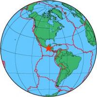
| Magnitude | 7.3 |
| Region | OFFSHORE GUATEMALA |
| Date time | 2012-11-07 16:35:48.1 UTC |
| Location | 14.065 ; -91.792 |
| Depth | 30 km |
| Distance | 91 km S of Quetzaltenango, Guatemala / pop: 132,000 / local time: 10:35:48.1 2012-11-07 29 km SE of Champerico, Guatemala / pop: 7,700 / local time: 10:35:48.1 2012-11-07 |
All data providers for this event:
Landsamt fur Geologie, Rohstoffe und Bergbau -- Freiburg, Germany (LED)Laboratoire de Detection et de Geophysique -- Bruyeres-le-Chatel, France (LDG)
GeoForschungsZentrum (GFZ) -- Potsdam, Germany (GFZ)
Norwegian Seismic Array -- Lillestrom, Norway (NORSAR)
Geophysical Survey of the Russian Academy of Sciences -- Obninsk, Russia (GSRAS)
Bundesanstalt fur Geowissenschaften und Rohstoffe, German Regional Seismograph Network -- Hannover, Germany (BGR)
National Earthquake Information Center, U.S. Geological Survey -- Golden, United States (NEIC)
GeoSphere Austria -- Vienna, Austria (GSA)
Pacific Tsunami Warning Center -- Honolulu, United States (PTWC)
Further information can be found at:
Servicio Sismologico Nacional, Instituto de Geofisica, UNAM -- Mexico City, Mexico (UNM)GeoForschungsZentrum (GFZ) -- Potsdam, Germany (GFZ)
National Earthquake Information Center, U.S. Geological Survey -- Golden, United States (NEIC)