| Magnitude | 2.3 |
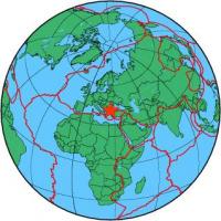
| Region | BULGARIA-GREECE-TURKEY BORDER RG |
| Date time | 2012-11-29 01:08:12.7 UTC |
| Location | 41.386 ; 26.454 |
| Depth | 9 km |
| Distance | 33 km S of Edirne, Turkey / pop: 126,000 / local time: 03:08:12.7 2012-11-29 14 km SSW of Orestiáda, Greece / pop: 16,200 / local time: 03:08:12.7 2012-11-29 |
All data providers for this event:
Kandilli Observatory and Earthquake Research Institute -- Istanbul, Turkey (KOERI)Further information can be found at:
Disaster and Emergency Management Presidency, Earthquake Department (AFAD) -- Ankara, Turkey (AFAD)Geophysical Survey of the Russian Academy of Sciences -- Obninsk, Russia (GSRAS)
Kandilli Observatory and Earthquake Research Institute -- Istanbul, Turkey (KOERI)
National Observatory of Athens, Geodynamic Institute -- Athens, Greece (NOA)
Aristotle University of Thessaloniki, Department of Geophysics -- Thessaloniki, Greece (THE)