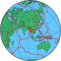
| Magnitude | 5.6 |
| Region | MYANMAR |
| Date time | 2013-04-03 16:35:46.4 UTC |
| Location | 19.299 ; 95.718 |
| Depth | 10 km |
| Distance | 66 km SSW of Nay Pyi Taw, Myanmar / pop: 925,000 / local time: 23:05:46.4 2013-04-03 56 km E of Thayetmyo, Myanmar / pop: 98,100 / local time: 23:05:46.4 2013-04-03 |
All data providers for this event:
Landsamt fur Geologie, Rohstoffe und Bergbau -- Freiburg, Germany (LED)National Institute for Earth Physics -- Bucharest, Romania (NIEP)
Laboratoire de Detection et de Geophysique -- Bruyeres-le-Chatel, France (LDG)
Montenegro Seismological Observatory -- Podgorica, Montenegro (MSO)
GeoForschungsZentrum (GFZ) -- Potsdam, Germany (GFZ)
Norwegian Seismic Array -- Lillestrom, Norway (NORSAR)
Republican Seismic Survey Center or Azerbaijan National Academy of Sciences -- Baku, Azerbaijan (RSSC)
Geophysical Survey of the Russian Academy of Sciences -- Obninsk, Russia (GSRAS)
Bundesanstalt fur Geowissenschaften und Rohstoffe, German Regional Seismograph Network -- Hannover, Germany (BGR)
National Earthquake Information Center, U.S. Geological Survey -- Golden, United States (NEIC)
GeoSphere Austria -- Vienna, Austria (GSA)
Further information can be found at:
National Earthquake Information Center, U.S. Geological Survey -- Golden, United States (NEIC)GeoForschungsZentrum (GFZ) -- Potsdam, Germany (GFZ)