| Magnitude | 6.0 |
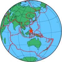
| Region | MORO GULF, MINDANAO, PHILIPPINES |
| Date time | 2010-05-31 10:15:59.7 UTC |
| Location | 6.992 ; 123.982 |
| Depth | 10 km |
| Distance | 39 km SW of Cotabato, Philippines / pop: 179,000 / local time: 18:15:59.7 2010-05-31 21 km WSW of Upi, Philippines / pop: 9,300 / local time: 18:15:59.7 2010-05-31 |
All data providers for this event:
National Institute for Earth Physics -- Bucharest, Romania (NIEP)GeoForschungsZentrum (GFZ) -- Potsdam, Germany (GFZ)
The research institute NORSAR -- Kjeller, Norway (NORSAR)
Republican Seismic Survey Center or Azerbaijan National Academy of Sciences -- Baku, Azerbaijan (RSSC)
Geophysical Survey of the Russian Academy of Sciences -- Obninsk, Russia (GSRAS)
National Earthquake Information Center, U.S. Geological Survey -- Golden, United States (NEIC)
Institute of Geophysics, University of Tehran -- Tehran, Iran (IGUT)
Further information can be found at:
Philippine Inst. of Volcanology and Seismology, Quezon City, Philippines -- Manila, Philippines (PIVS)National Earthquake Information Center, U.S. Geological Survey -- Golden, United States (NEIC)
Badan Meteorologi, Klimatologi dan Geofisika -- Jakarta, Indonesia (BMKG)
GeoForschungsZentrum (GFZ) -- Potsdam, Germany (GFZ)