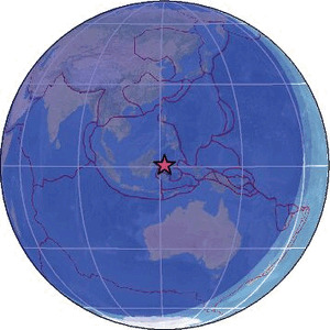
| Magnitude | 4.5 |
| Region | MINAHASA, SULAWESI, INDONESIA |
| Date time | 2026-02-17 17:30:48.8 UTC |
| Location | 0.473 ; 121.643 |
| Depth | 109 km |
| Distance | 250 km NE of Palu, Indonesia / pop: 282,000 / local time: 01:30:48.8 2026-02-18 158 km WSW of Gorontalo, Indonesia / pop: 144,000 / local time: 01:30:48.8 2026-02-18 |
Source parameters reviewed by a seismologist
All data providers for this event:
Badan Meteorologi, Klimatologi dan Geofisika -- Jakarta, Indonesia (BMKG)GeoForschungsZentrum (GFZ) -- Potsdam, Germany (GFZ)
Malaysian Meteorological Department -- Kuala Lumpur, Malaysia (MET)
National Earthquake Information Center, U.S. Geological Survey -- Golden, United States (NEIC)
Further information can be found at:
GeoForschungsZentrum (GFZ) -- Potsdam, Germany (GFZ)Badan Meteorologi, Klimatologi dan Geofisika -- Jakarta, Indonesia (BMKG)
National Earthquake Information Center, U.S. Geological Survey -- Golden, United States (NEIC)
Philippine Inst. of Volcanology and Seismology, Quezon City, Philippines -- Manila, Philippines (PIVS)