| Magnitude | 4.6 |
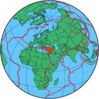
| Region | CENTRAL TURKEY |
| Date time | 2012-07-22 09:26:04.3 UTC |
| Location | 37.550 ; 36.380 |
| Depth | 7 km |
| Distance | 48 km WSW of Kahramanmaraş, Türkiye / pop: 376,000 / local time: 12:26:04.3 2012-07-22 4 km SE of Andırın, Türkiye / pop: 8,600 / local time: 12:26:04.3 2012-07-22 |
All data providers for this event:
Landsamt fur Geologie, Rohstoffe und Bergbau -- Freiburg, Germany (LED)Instituto Geografico Nacional -- Madrid, Spain (IGN)
National Institute for Earth Physics -- Bucharest, Romania (NIEP)
Seismological Survey of Serbia -- Belgrade, Serbia (BEO)
Laboratoire de Detection et de Geophysique -- Bruyeres-le-Chatel, France (LDG)
GeoForschungsZentrum (GFZ) -- Potsdam, Germany (GFZ)
Geophysical Survey of the Russian Academy of Sciences -- Obninsk, Russia (GSRAS)
Kandilli Observatory and Earthquake Research Institute -- Istanbul, Türkiye (KOERI)
Bundesanstalt fur Geowissenschaften und Rohstoffe, German Regional Seismograph Network -- Hannover, Germany (BGR)
Cyprus Geological Survey Department -- Nicosia, Cyprus (GSD)
National Earthquake Information Center, U.S. Geological Survey -- Golden, United States (NEIC)
Disaster and Emergency Management Presidency, Earthquake Department (AFAD) -- Ankara, Türkiye (AFAD)
GeoSphere Austria -- Vienna, Austria (GSA)
Further information can be found at:
Kandilli Observatory and Earthquake Research Institute -- Istanbul, Türkiye (KOERI)Geophysical Survey of the Russian Academy of Sciences -- Obninsk, Russia (GSRAS)
Disaster and Emergency Management Presidency, Earthquake Department (AFAD) -- Ankara, Türkiye (AFAD)