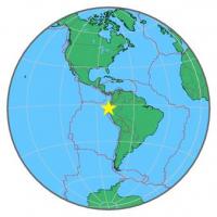
| Magnitude | 5.0 |
| Region | PERU-ECUADOR BORDER REGION |
| Date time | 2015-03-19 11:52:00.5 UTC |
| Location | -3.282 ; -80.523 |
| Depth | 56 km |
| Distance | 62 km WSW of Machala, Ecuador / pop: 198,000 / local time: 06:52:00.5 2015-03-19 33 km NNW of Tumbes, Peru / pop: 109,000 / local time: 06:52:00.5 2015-03-19 |
All data providers for this event:
GeoForschungsZentrum (GFZ) -- Potsdam, Germany (GFZ)Inst. de Astron., Geof. e Ciencias Atmos., Univ. de S?o Paulo, Brazil -- , Brazil (VAO)
British Geological Survey (Global Network) -- Edinburgh, United Kingdom (BGSG)
Geophysical Survey of the Russian Academy of Sciences -- Obninsk, Russia (GSRAS)
National Earthquake Information Center, U.S. Geological Survey -- Golden, United States (NEIC)
Further information can be found at:
Instituto Geofisico del Peru -- Lima, Peru (LIM)National Earthquake Information Center, U.S. Geological Survey -- Golden, United States (NEIC)
GeoForschungsZentrum (GFZ) -- Potsdam, Germany (GFZ)
Escuela Politecnica Nacional, Quito, Ecuador -- Quito, Ecuador (QUI)