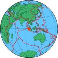
| Magnitude | 5.1 |
| Region | KEP. MENTAWAI REGION, INDONESIA |
| Date time | 2009-08-16 18:42:25.4 UTC |
| Location | -1.470 ; 99.306 |
| Depth | 30 km |
| Distance | 555 km SSW of Klang, Malaysia / pop: 879,000 / local time: 02:42:25.4 2009-08-17 130 km SW of Padang, Indonesia / pop: 840,000 / local time: 01:42:25.4 2009-08-17 |
All data providers for this event:
Further information can be found at:
GeoForschungsZentrum (GFZ) -- Potsdam, Germany (GFZ)National Earthquake Information Center, U.S. Geological Survey -- Golden, United States (NEIC)
Badan Meteorologi, Klimatologi dan Geofisika -- Jakarta, Indonesia (BMKG)