| Magnitude | 6.4 |
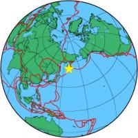
| Region | OFF EAST COAST OF KAMCHATKA |
| Date time | 2010-07-30 03:56:16.3 UTC |
| Location | 52.475 ; 159.963 |
| Depth | 40 km |
| Distance | 1596 km E of Komsomolsk-on-Amur, Russia / pop: 275,000 / local time: 14:56:16.3 2010-07-30 111 km ESE of Petropavlovsk-Kamchatsky, Russia / pop: 187,000 / local time: 15:56:16.3 2010-07-30 |
All data providers for this event:
Norwegian Seismic Array -- Kjeller, Norway (NOR)Landsamt fur Geologie, Rohstoffe und Bergbau -- Freiburg, Germany (LED)
National Institute for Earth Physics -- Bucharest, Romania (NIEP)
Geophysical Institute of the Academy of Sciences -- Prague, Czech Republic (GFU)
Laboratoire de Detection et de Geophysique -- Bruyeres-le-Chatel, France (LDG)
Montenegro Seismological Observatory -- Podgorica, Montenegro (MSO)
GeoForschungsZentrum (GFZ) -- Potsdam, Germany (GFZ)
Norwegian Seismic Array -- Lillestrom, Norway (NORSAR)
Republican Seismic Survey Center or Azerbaijan National Academy of Sciences -- Baku, Azerbaijan (RSSC)
Geophysical Survey of the Russian Academy of Sciences -- Obninsk, Russia (GSRAS)
Bundesanstalt fur Geowissenschaften und Rohstoffe, German Regional Seismograph Network -- Hannover, Germany (BGR)
National Earthquake Information Center, U.S. Geological Survey -- Golden, United States (NEIC)
GeoSphere Austria -- Vienna, Austria (GSA)
Further information can be found at:
Geophysical Survey of the Russian Academy of Sciences -- Obninsk, Russia (GSRAS)National Earthquake Information Center, U.S. Geological Survey -- Golden, United States (NEIC)
GeoForschungsZentrum (GFZ) -- Potsdam, Germany (GFZ)