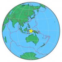
| Magnitude | 4.4 |
| Region | SERAM, INDONESIA |
| Date time | 2014-10-04 04:05:08.9 UTC |
| Location | -2.855 ; 129.632 |
| Depth | 51 km |
| Distance | 186 km NE of Ambon, Indonesia / pop: 355,000 / local time: 13:05:08.9 2014-10-04 96 km NE of Amahai, Indonesia / pop: 47,600 / local time: 13:05:08.9 2014-10-04 |
All data providers for this event:
GeoForschungsZentrum (GFZ) -- Potsdam, Germany (GFZ)National Earthquake Information Center, U.S. Geological Survey -- Golden, United States (NEIC)
Further information can be found at:
Badan Meteorologi, Klimatologi dan Geofisika -- Jakarta, Indonesia (BMKG)National Earthquake Information Center, U.S. Geological Survey -- Golden, United States (NEIC)
GeoForschungsZentrum (GFZ) -- Potsdam, Germany (GFZ)