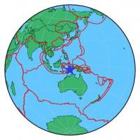
| Magnitude | 4.0 |
| Region | BANDA SEA |
| Date time | 2015-04-07 16:19:58.2 UTC |
| Location | -6.764 ; 129.717 |
| Depth | 159 km |
| Distance | 381 km SE of Ambon, Indonesia / pop: 355,000 / local time: 01:19:58.2 2015-04-08 359 km WSW of Tual, Indonesia / pop: 39,500 / local time: 01:19:58.2 2015-04-08 |
All data providers for this event:
National Earthquake Information Center, U.S. Geological Survey -- Golden, United States (NEIC)Further information can be found at:
GeoForschungsZentrum (GFZ) -- Potsdam, Germany (GFZ)Badan Meteorologi, Klimatologi dan Geofisika -- Jakarta, Indonesia (BMKG)
National Earthquake Information Center, U.S. Geological Survey -- Golden, United States (NEIC)