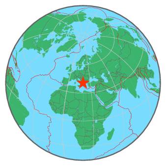
tempDisclaimer
M 4.7 - ALBANIA - 2017-01-27 17:07:58 UTC
I felt this earthquake
Summary | Maps | Testimonies | Pictures | List of data providers | Scientific data |
| ![]() |
More information at: |
Earthquake View | Interactive Maps View | I felt this earthquake | Contribution Map |
Seismicity | Regional Moment tensors | Quick MT solutions | PGA/PGV/Population |
Int_Dist | Dist_Time | Donut |
No enough data for Intensity/Distance curve
For more information on computation, see the article Bossu et al., 2016:
- Thumbnail Based Questionnaires for the Rapid and Efficient Collection of Macroseismic Data from Global Earthquakes, Rémy Bossu, Matthieu Landès, Fréderic Roussel, Robert Steed, Gilles Mazet-Roux, Stacey S. Martin, and Susan Hough. Seismological Research Letter. Oct 2016. doi: 10.1785/0220160120;
- Furthermore, to avoid the association with wrong events, we filter testimonies in distance and in intensity depending on the magnitude of the seismic event.
Global view | Regional view | Local view |
References for tectonic plate boundaries:
Coffin, M.F., Gahagan, L.M., and Lawver, L.A., 1998, Present-day Plate Boundary Digital Data Compilation. University of Texas Institute for Geophysics Technical Report No. 174, pp. 5.
Maps view: Seismicity from the previous 7 days in the area |
This seismicity maps have been generated by concatenating the ISC catalogue (since 1964), the EMSC Euro-Med Bulletin catalogue and the EMSC Real Time catalogue. Therefore, they show the seismicity from 1964 until the earthquake occurrence.
Date | Long. | Lat. | Mag. | Death | Location |
1566-07-11 | 21.7 | 39.0 | 6.5 | many | GREECE |
1630-07-22 | 20.9 | 38.3 | 6.9 | many | GREECE |
1658-08-24 | 20.5 | 38.3 | 6.8 | 320 | GREECE |
1667-04-06 | 18.1 | 42.6 | 7.2 | 5000 | CROATIA-BOSNIA-MONTENEGRO REGION |
1674-01-01 | 20.0 | 39.5 | 6.5 | 200 | GREECE-ALBANIA BORDER REGION |
1701-03-19 | 19.8 | 40.2 | 6.4 | 300 | ALBANIA |
1704-11-22 | 20.7 | 38.7 | 6.6 | 34 | GREECE |
1723-02-22 | 20.7 | 38.6 | 7.0 | many | GREECE |
1743-02-20 | 18.8 | 39.9 | 7.3 | 180 | SOUTHERN ITALY |
1759-06-22 | 23.1 | 40.7 | 6.5 | many | GREECE |
1767-07-11 | 20.3 | 38.2 | 7.2 | 253 | GREECE |
1783-03-23 | 20.5 | 38.6 | 7.0 | 35 | GREECE |
1786-02-05 | 19.9 | 39.6 | 6.6 | 126 | GREECE-ALBANIA BORDER REGION |
1823-10-00 | 18.2 | 42.7 | ? | many | CROATIA-BOSNIA-MONTENEGRO REGION |
1825-01-19 | 20.7 | 38.8 | 6.8 | 58 | GREECE |
1851-10-12 | 19.7 | 40.7 | 6.6 | 2000 | ALBANIA |
1851-10-17 | 20.0 | 40.7 | ? | 400 | GREECE-ALBANIA BORDER REGION |
1854-07-30 | 20.2 | 39.9 | 6.4 | many | GREECE-ALBANIA BORDER REGION |
1866-01-02 | 19.5 | 40.4 | 6.5 | 60 | ALBANIA |
1867-02-04 | 20.4 | 38.2 | 7.3 | 224 | GREECE |
1895-05-14 | 20.5 | 39.4 | 6.6 | many | GREECE-ALBANIA BORDER REGION |
1905-06-01 | 19.5 | 42.1 | 6.6 | 120 | ALBANIA-SERBIA-MONTENEGRO BORDER |
1909-06-15 | 22.2 | 39.1 | 5.7 | 36 | GREECE |
1920-11-26 | 20.0 | 40.3 | 6.3 | 200 | GREECE-ALBANIA BORDER REGION |
1927-02-14 | 18.0 | 43.0 | 6.1 | 50 | BOSNIA AND HERZEGOVINA REGION |
1930-11-21 | 19.6 | 40.2 | 6.0 | 35 | ALBANIA |
1930-12-02 | 19.6 | 40.3 | 5.0 | 25 | ALBANIA |
1931-01-28 | 20.7 | 40.6 | 5.9 | 100 | GREECE-ALBANIA BORDER REGION |
1931-03-08 | 22.5 | 41.3 | 6.7 | 35 | FYR OF MACEDONIA REGION |
1932-09-29 | 23.2 | 41.0 | 6.2 | 318 | GREECE-BULGARIA BORDER REGION |
1942-08-27 | 20.4 | 41.6 | 5.9 | 43 | ALBANIA-FYR OF MACEDONIA BDR REG |
1953-08-12 | 20.6 | 38.3 | 7.2 | 800 | GREECE |
1954-04-30 | 22.3 | 39.3 | 7.0 | 31 | GREECE |
1963-07-26 | 21.4 | 42.0 | 6.1 | 1070 | SERBIA-FYR OF MACEDONIA BORD REG |
1978-06-20 | 23.3 | 40.6 | 6.5 | 45 | GREECE |
1979-04-15 | 19.2 | 42.1 | 6.9 | 129 | ALBANIA-SERBIA-MONTENEGRO BORDER |
2002-04-24 | 21.5 | 42.4 | 5.7 | 1 | KOSOVO-SERBIA-N MAC. BORDER REG. |
2015-11-17 | 20.4 | 38.8 | 6.5 | 2 | GREECE |
Source:
- From 1500 to 1999: T. Utsu ; International Handbook of Earthquake and Engineering Seismology; vol. A; 691-718
- From 2000 to 2007: USGS Quality composite earthquake catalog
- From 2008: National Centers for Environmental Information (NOAA)
MapGraphsClustering


