| Magnitude | 5.5 |
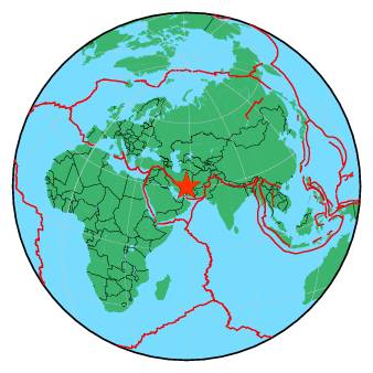
| Region | EASTERN IRAN |
| Date time | 2018-07-22 20:39:16.4 UTC |
| Location | 30.286 ; 57.533 |
| Depth | 10 km |
| Distance | 488 km ENE of Shiraz, Iran / pop: 1,249,000 / local time: 01:09:16.4 2018-07-23 44 km E of Kerman, Iran / pop: 577,000 / local time: 01:09:16.4 2018-07-23 |
All data providers for this event:
Seismological Survey of Serbia -- Belgrade, Serbia (BEO)GeoForschungsZentrum (GFZ) -- Potsdam, Germany (GFZ)
Red Sismica Nacional de Colombia, INGEOMINAS, Bogota, Colombia -- Bogota, Colombia (RSNC)
Republican Seismic Survey Center or Azerbaijan National Academy of Sciences -- Baku, Azerbaijan (RSSC)
Instituto Portugues do Mar e da Atmosfera -- Lisbon, Portugal (IPMA)
National Earthquake Information Center, U.S. Geological Survey -- Golden, United States (NEIC)
Institute of Geophysics, University of Tehran -- Tehran, Iran (IGUT)
Instituto Geografico Nacional -- Madrid, Spain (IGN)
National Institute for Earth Physics -- Bucharest, Romania (NIEP)
Laboratoire de Detection et de Geophysique -- Bruyeres-le-Chatel, France (LDG)
HUN-REN EPSS Kövesligethy Radó Seismological Observato -- Budapest, Hungary (BUD)
Geophysical Survey of the Russian Academy of Sciences -- Obninsk, Russia (GSRAS)
Kandilli Observatory and Earthquake Research Institute -- Istanbul, Türkiye (KOERI)
Further information can be found at:
Geophysical Survey of the Russian Academy of Sciences -- Obninsk, Russia (GSRAS)International Institute for Earthquake Engineering and Seismology -- Tehran, Iran (IIEES)
Institute of Geophysics, University of Tehran -- Tehran, Iran (IGUT)