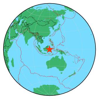
| Magnitude | 5.4 |
| Region | MINAHASA, SULAWESI, INDONESIA |
| Date time | 2018-09-28 10:39:02.7 UTC |
| Location | -0.638 ; 119.946 |
| Depth | 10 km |
| Distance | 312 km E of Samarinda, Indonesia / pop: 355,000 / local time: 18:39:02.7 2018-09-28 31 km N of Palu, Indonesia / pop: 282,000 / local time: 18:39:02.7 2018-09-28 |
All data providers for this event:
Geoscience Australia, Canberra, ACT, Australia -- Canberra, Australia (AUST)Ukrainian NDC, Main Center of Special Monitoring -- Kyiv, Ukraine (MCSM)
GeoForschungsZentrum (GFZ) -- Potsdam, Germany (GFZ)
Geophysical Survey of the Russian Academy of Sciences -- Obninsk, Russia (GSRAS)
National Earthquake Information Center, U.S. Geological Survey -- Golden, United States (NEIC)
Further information can be found at:
National Earthquake Information Center, U.S. Geological Survey -- Golden, United States (NEIC)Badan Meteorologi, Klimatologi dan Geofisika -- Jakarta, Indonesia (BMKG)
GeoForschungsZentrum (GFZ) -- Potsdam, Germany (GFZ)