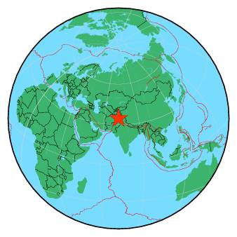
On Tuesday, March 21st, our services will be unavailable between 12h30-14h CET. We will inform you as soon as the technical operation is completed. Thank you for your patience
101 km NE of PeshÄwar, Pakistan / pop: 1,219,000 / local time: 17:39:07.6 2019-06-16
55 km N of SwÄbi, Pakistan / pop: 97,400 / local time: 17:39:07.6 2019-06-16
19 km S of MingÄora, Pakistan / pop: 228,000 / local time: 17:39:07.6 2019-06-16
For more information on computation, see the article Bossu et al., 2016:
Thumbnail Based Questionnaires for the Rapid and Efficient Collection of Macroseismic Data from Global Earthquakes, Rémy Bossu, Matthieu Landès, Fréderic Roussel, Robert Steed, Gilles Mazet-Roux, Stacey S. Martin, and Susan Hough. Seismological Research Letter. Oct 2016. doi: 10.1785/0220160120;
Furthermore, to avoid the association with wrong events, we filter testimonies in distance and in intensity depending on the magnitude of the seismic event.
References for tectonic plate boundaries:
Coffin, M.F., Gahagan, L.M., and Lawver, L.A., 1998, Present-day Plate Boundary Digital Data Compilation. University of Texas Institute for Geophysics Technical Report No. 174, pp. 5.
Maps view: Seismicity from the previous 7 days in the area .
Regional instrumental seismicity
This seismicity maps have been generated by concatenating the ISC catalogue (since 1964), the EMSC Euro-Med Bulletin catalogue and the EMSC Real Time catalogue. Therefore, they show the seismicity from 1964 until the earthquake occurrence.
Regional deadly earthquakes from 1500 to origin time
Date
Long.
Lat.
Mag.
Death
Location
1505-07-06
69.2
34.7
?
great
CENTRAL AFGHANISTAN
1828-06-06
74.5
34.2
?
1000
SOUTHWESTERN KASHMIR
1832-01-22
71.0
36.5
7.4
great
AFGHAN-TAJIKISTAN-PAKISTAN REG.
1842-02-19
70.5
34.4
?
500
HINDU KUSH REGION, AFGHANISTAN
1885-05-30
75.0
33.5
?
3000
EASTERN KASHMIR
1963-09-02
74.8
33.9
5.3
80
SOUTHWESTERN KASHMIR
1972-09-03
73.4
36.0
6.5
100
NORTHWESTERN KASHMIR
1974-12-28
72.8
35.0
6.2
5300
PAKISTAN
1981-09-12
73.6
35.7
6.1
229
NORTHWESTERN KASHMIR
1990-07-13
70.8
36.4
5.6
43
HINDU KUSH REGION, AFGHANISTAN
1991-01-31
70.4
36.0
6.4
703
HINDU KUSH REGION, AFGHANISTAN
1992-05-20
71.3
33.4
6.0
36
PAKISTAN
1999-02-11
69.4
34.3
5.8
70
CENTRAL AFGHANISTAN
2000-07-17
70.9
36.2
6.3
2
HINDU KUSH REGION, AFGHANISTAN
2001-06-01
69.3
35.1
5.0
4
HINDU KUSH REGION, AFGHANISTAN
2002-03-03
70.5
36.4
7.3
166
HINDU KUSH REGION, AFGHANISTAN
2002-11-01
74.6
35.4
5.3
11
NORTHWESTERN KASHMIR
2002-11-20
74.5
35.3
6.3
19
NORTHWESTERN KASHMIR
2003-03-29
70.5
35.9
5.8
1
HINDU KUSH REGION, AFGHANISTAN
2004-02-14
73.2
34.8
5.4
24
PAKISTAN
2004-04-05
71.0
36.5
6.5
3
HINDU KUSH REGION, AFGHANISTAN
2005-10-08
73.6
34.5
7.6
87351
PAKISTAN
2005-10-15
73.9
34.0
5.2
2
PAKISTAN
2005-12-12
71.1
36.3
6.5
5
HINDU KUSH REGION, AFGHANISTAN
2006-03-10
73.9
33.1
4.9
1
PAKISTAN
2009-04-16
70.1
34.1
5.4
19
HINDU KUSH REGION, AFGHANISTAN
2009-10-22
71.0
36.5
6.2
5
HINDU KUSH REGION, AFGHANISTAN
2010-10-10
72.9
34.0
5.2
1
PAKISTAN
2013-04-24
70.3
34.6
5.5
18
HINDU KUSH REGION, AFGHANISTAN
2015-07-24
73.3
33.9
5.1
3
PAKISTAN
2015-10-26
70.9
36.5
7.5
399
HINDU KUSH REGION, AFGHANISTAN
2015-12-25
71.3
36.5
6.3
4
HINDU KUSH REGION, AFGHANISTAN
2016-04-10
71.3
36.5
6.6
6
HINDU KUSH REGION, AFGHANISTAN
2016-10-01
73.7
34.9
5.3
1
PAKISTAN
2018-01-31
70.9
36.5
6.1
2
HINDU KUSH REGION, AFGHANISTAN
Source:
From 1500 to 1999: T. Utsu ; International Handbook of Earthquake and Engineering Seismology; vol. A; 691-718