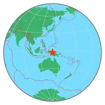
| Magnitude | 5.4 |
| Region | NEAR N COAST OF PAPUA, INDONESIA |
| Date time | 2021-02-16 19:09:38.2 UTC |
| Location | -2.893 ; 139.199 |
| Depth | 25 km |
| Distance | 173 km WSW of Jayapura, Indonesia / pop: 134,000 / local time: 04:09:38.2 2021-02-17 163 km WSW of Abepura, Indonesia / pop: 62,200 / local time: 04:09:38.2 2021-02-17 |
All data providers for this event:
Geoscience Australia, Canberra, ACT, Australia -- Canberra, Australia (AUST)Centro de Sismologia da Universidade de Sao Paulo (member of the RSBR) -- Sao Paulo, Brazil (USP)
GeoForschungsZentrum (GFZ) -- Potsdam, Germany (GFZ)
Badan Meteorologi, Klimatologi dan Geofisika -- Jakarta, Indonesia (BMKG)
Geophysical Survey of the Russian Academy of Sciences -- Obninsk, Russia (GSRAS)
Kandilli Observatory and Earthquake Research Institute -- Istanbul, Türkiye (KOERI)
National Earthquake Information Center, U.S. Geological Survey -- Golden, United States (NEIC)
Further information can be found at:
National Earthquake Information Center, U.S. Geological Survey -- Golden, United States (NEIC)Badan Meteorologi, Klimatologi dan Geofisika -- Jakarta, Indonesia (BMKG)
GeoForschungsZentrum (GFZ) -- Potsdam, Germany (GFZ)