| Magnitude | 2.0 |
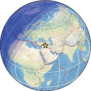
| Region | SYRIA-IRAQ BORDER REGION |
| Date time | 2026-01-27 06:13:23.0 UTC |
| Location | 36.306 ; 41.718 |
| Depth | 7 km |
| Distance | 124 km WSW of Al Mawşil al Jadīdah, Iraq / pop: 2,065,000 / local time: 09:13:23.0 2026-01-27 14 km WSW of Sinjār, Iraq / pop: 38,200 / local time: 09:13:23.0 2026-01-27 |
Source parameters provided by:
Disaster and Emergency Management Presidency, Earthquake Department (AFAD) -- Ankara, Türkiye (AFAD)
All data providers for this event:
Disaster and Emergency Management Presidency, Earthquake Department (AFAD) -- Ankara, Türkiye (AFAD)Further information can be found at:
Disaster and Emergency Management Presidency, Earthquake Department (AFAD) -- Ankara, Türkiye (AFAD)Kandilli Observatory and Earthquake Research Institute -- Istanbul, Türkiye (KOERI)