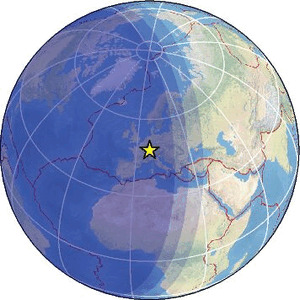
| Magnitude | 1.7 |
| Region | FRANCE-GERMANY BORDER REGION |
| Date time | 2026-01-31 04:18:59.2 UTC |
| Location | 48.035 ; 7.504 |
| Depth | 10 km |
| Distance | 26 km W of Freiburg, Germany / pop: 215,000 / local time: 05:18:59.2 2026-01-31 12 km ESE of Colmar, France / pop: 65,400 / local time: 05:18:59.2 2026-01-31 |
Source parameters provided by:
All data providers for this event:
Landsamt fur Geologie, Rohstoffe und Bergbau -- Freiburg, Germany (LED)Reseau National de Surveillance Sismique -- Strasbourg, France (ReNaSS)
Swiss Seismological Service -- Zurich, Switzerland (ETHZ)
Further information can be found at:
Laboratoire de Detection et de Geophysique -- Bruyeres-le-Chatel, France (LDG)Reseau National de Surveillance Sismique -- Strasbourg, France (ReNaSS)
Bundesanstalt fur Geowissenschaften und Rohstoffe, German Regional Seismograph Network -- Hannover, Germany (BGR)
Landsamt fur Geologie, Rohstoffe und Bergbau -- Freiburg, Germany (LED)