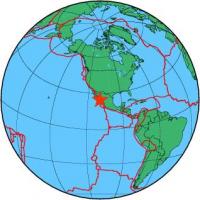
| Magnitude | 6.7 |
| Region | GULF OF CALIFORNIA |
| Date time | 2010-10-21 17:53:14.8 UTC |
| Location | 24.821 ; -109.212 |
| Depth | 10 km |
| Distance | 110 km S of Los Mochis, Mexico / pop: 256,000 / local time: 11:53:14.8 2010-10-21 88 km S of Topolobampo, Mexico / pop: 6,300 / local time: 11:53:14.8 2010-10-21 |
All data providers for this event:
Laboratoire de Detection et de Geophysique -- Bruyeres-le-Chatel, France (LDG)GeoForschungsZentrum (GFZ) -- Potsdam, Germany (GFZ)
The research institute NORSAR -- Kjeller, Norway (NORSAR)
Geophysical Survey of the Russian Academy of Sciences -- Obninsk, Russia (GSRAS)
Bundesanstalt fur Geowissenschaften und Rohstoffe, German Regional Seismograph Network -- Hannover, Germany (BGR)
National Earthquake Information Center, U.S. Geological Survey -- Golden, United States (NEIC)
Further information can be found at:
National Earthquake Information Center, U.S. Geological Survey -- Golden, United States (NEIC)Servicio Sismologico Nacional, Instituto de Geofisica, UNAM -- Mexico City, Mexico (UNM)
GeoForschungsZentrum (GFZ) -- Potsdam, Germany (GFZ)