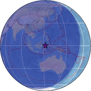
| Magnitude | 4.6 |
| Region | MINAHASA, SULAWESI, INDONESIA |
| Date time | 2026-02-25 18:11:59.4 UTC |
| Location | 0.208 ; 122.083 |
| Depth | 184 km |
| Distance | 275 km NE of Palu, Indonesia / pop: 282,000 / local time: 02:11:59.4 2026-02-26 115 km WSW of Gorontalo, Indonesia / pop: 144,000 / local time: 02:11:59.4 2026-02-26 |
Source parameters reviewed by a seismologist
All data providers for this event:
Badan Meteorologi, Klimatologi dan Geofisika -- Jakarta, Indonesia (BMKG)GeoForschungsZentrum (GFZ) -- Potsdam, Germany (GFZ)
Geonet, GNS science -- Lower Hutt, New Zealand (GNS)
Geophysical Survey of the Russian Academy of Sciences -- Obninsk, Russia (GSRAS)
Malaysian Meteorological Department -- Kuala Lumpur, Malaysia (MET)
National Earthquake Information Center, U.S. Geological Survey -- Golden, United States (NEIC)
Further information can be found at:
GeoForschungsZentrum (GFZ) -- Potsdam, Germany (GFZ)Badan Meteorologi, Klimatologi dan Geofisika -- Jakarta, Indonesia (BMKG)
National Earthquake Information Center, U.S. Geological Survey -- Golden, United States (NEIC)
Philippine Inst. of Volcanology and Seismology, Quezon City, Philippines -- Manila, Philippines (PIVS)