| Magnitude | 2.0 |
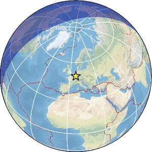
| Region | FRANCE-GERMANY BORDER REGION |
| Date time | 2026-03-31 10:26:04.8 UTC |
| Location | 49.616 ; 6.658 |
| Depth | 0 km |
| Distance | 16 km SSE of Trier, Germany / pop: 100,000 / local time: 12:26:04.8 2026-03-31 11 km SE of Konz, Germany / pop: 17,800 / local time: 12:26:04.8 2026-03-31 |
Source parameters provided by:
Reseau National de Surveillance Sismique -- Strasbourg, France (ReNaSS)
All data providers for this event:
Reseau National de Surveillance Sismique -- Strasbourg, France (ReNaSS)Further information can be found at:
Landsamt fur Geologie, Rohstoffe und Bergbau -- Freiburg, Germany (LED)Bundesanstalt fur Geowissenschaften und Rohstoffe, German Regional Seismograph Network -- Hannover, Germany (BGR)
Reseau National de Surveillance Sismique -- Strasbourg, France (ReNaSS)
Laboratoire de Detection et de Geophysique -- Bruyeres-le-Chatel, France (LDG)