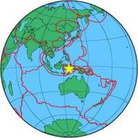
| Magnitude | 4.5 |
| Region | BURU, INDONESIA |
| Date time | 2011-02-18 08:10:30.2 UTC |
| Location | -3.545 ; 126.663 |
| Depth | 42 km |
| Distance | 570 km N of Dili, Timor Leste / pop: 150,000 / local time: 17:10:30.2 2011-02-18 170 km W of Ambon, Indonesia / pop: 355,000 / local time: 17:10:30.2 2011-02-18 |
All data providers for this event:
National Earthquake Information Center, U.S. Geological Survey -- Golden, United States (NEIC)Further information can be found at:
National Earthquake Information Center, U.S. Geological Survey -- Golden, United States (NEIC)GeoForschungsZentrum (GFZ) -- Potsdam, Germany (GFZ)
Badan Meteorologi, Klimatologi dan Geofisika -- Jakarta, Indonesia (BMKG)