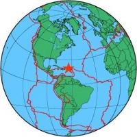
| Magnitude | 4.7 |
| Region | NORTH OF THE VIRGIN ISLANDS |
| Date time | 2012-09-28 15:36:20.5 UTC |
| Location | 19.867 ; -64.332 |
| Depth | 10 km |
| Distance | 181 km N of Charlotte Amalie, U.S. Virgin Islands / pop: 20,000 / local time: 11:36:20.5 2012-09-28 163 km N of Road Town, British Virgin Islands / pop: 8,400 / local time: 11:36:20.5 2012-09-28 |
All data providers for this event:
GeoForschungsZentrum (GFZ) -- Potsdam, Germany (GFZ)Geophysical Survey of the Russian Academy of Sciences -- Obninsk, Russia (GSRAS)
National Earthquake Information Center, U.S. Geological Survey -- Golden, United States (NEIC)
Further information can be found at:
National Earthquake Information Center, U.S. Geological Survey -- Golden, United States (NEIC)GeoForschungsZentrum (GFZ) -- Potsdam, Germany (GFZ)