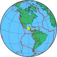
| Magnitude | 4.2 |
| Region | CHIAPAS, MEXICO |
| Date time | 2012-11-21 05:13:43.3 UTC |
| Location | 16.409 ; -90.889 |
| Depth | 42 km |
| Distance | 188 km N of Quetzaltenango, Guatemala / pop: 132,000 / local time: 23:13:43.3 2012-11-20 16 km WNW of Zamora Pico de Oro, Mexico / pop: 1,700 / local time: 23:13:43.3 2012-11-20 |
All data providers for this event:
National Earthquake Information Center, U.S. Geological Survey -- Golden, United States (NEIC)Further information can be found at:
National Earthquake Information Center, U.S. Geological Survey -- Golden, United States (NEIC)GeoForschungsZentrum (GFZ) -- Potsdam, Germany (GFZ)
Servicio Sismologico Nacional, Instituto de Geofisica, UNAM -- Mexico City, Mexico (UNM)