| Magnitude | 5.0 |
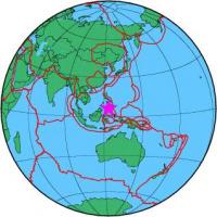
| Region | MORO GULF, MINDANAO, PHILIPPINES |
| Date time | 2012-11-24 20:28:51.0 UTC |
| Location | 6.525 ; 123.541 |
| Depth | 622 km |
| Distance | 110 km SW of Cotabato, Philippines / pop: 179,000 / local time: 04:28:51.0 2012-11-25 56 km WSW of Kalamansig, Philippines / pop: 12,800 / local time: 04:28:51.0 2012-11-25 |
All data providers for this event:
Seismological Survey of Serbia -- Belgrade, Serbia (BEO)GeoForschungsZentrum (GFZ) -- Potsdam, Germany (GFZ)
Geophysical Survey of the Russian Academy of Sciences -- Obninsk, Russia (GSRAS)
National Earthquake Information Center, U.S. Geological Survey -- Golden, United States (NEIC)
Further information can be found at:
Badan Meteorologi, Klimatologi dan Geofisika -- Jakarta, Indonesia (BMKG)National Earthquake Information Center, U.S. Geological Survey -- Golden, United States (NEIC)
Philippine Inst. of Volcanology and Seismology, Quezon City, Philippines -- Manila, Philippines (PIVS)
GeoForschungsZentrum (GFZ) -- Potsdam, Germany (GFZ)