| Magnitude | 5.6 |
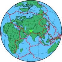
| Region | HINDU KUSH REGION, AFGHANISTAN |
| Date time | 2012-12-29 17:50:52.8 UTC |
| Location | 35.721 ; 70.626 |
| Depth | 117 km |
| Distance | 145 km N of Jalālābād, Afghanistan / pop: 200,000 / local time: 22:20:52.8 2012-12-29 43 km NW of Pārūn, Afghanistan / pop: 1,000 / local time: 22:20:52.8 2012-12-29 |
All data providers for this event:
Instituto Geografico Nacional -- Madrid, Spain (IGN)Landsamt fur Geologie, Rohstoffe und Bergbau -- Freiburg, Germany (LED)
Seismological Survey of Serbia -- Belgrade, Serbia (BEO)
Laboratoire de Detection et de Geophysique -- Bruyeres-le-Chatel, France (LDG)
Montenegro Seismological Observatory -- Podgorica, Montenegro (MSO)
GeoForschungsZentrum (GFZ) -- Potsdam, Germany (GFZ)
The research institute NORSAR -- Kjeller, Norway (NORSAR)
Geophysical Survey of the Russian Academy of Sciences -- Obninsk, Russia (GSRAS)
Bundesanstalt fur Geowissenschaften und Rohstoffe, German Regional Seismograph Network -- Hannover, Germany (BGR)
National Earthquake Information Center, U.S. Geological Survey -- Golden, United States (NEIC)
Kazakhstan National Data Center -- Almaty, Kazakhstan (KNDC)
GeoSphere Austria -- Vienna, Austria (GSA)
Further information can be found at:
GeoForschungsZentrum (GFZ) -- Potsdam, Germany (GFZ)National Earthquake Information Center, U.S. Geological Survey -- Golden, United States (NEIC)
Geophysical Survey of the Russian Academy of Sciences -- Obninsk, Russia (GSRAS)