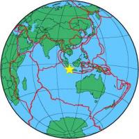
| Magnitude | 5.1 |
| Region | SUNDA STRAIT, INDONESIA |
| Date time | 2013-02-02 01:19:36.9 UTC |
| Location | -6.990 ; 105.374 |
| Depth | 56 km |
| Distance | 119 km SW of Rangkasbitung, Indonesia / pop: 126,000 / local time: 08:19:36.9 2013-02-02 85 km SSW of Labuan, Indonesia / pop: 33,500 / local time: 08:19:36.9 2013-02-02 |
All data providers for this event:
National Institute for Earth Physics -- Bucharest, Romania (NIEP)GeoForschungsZentrum (GFZ) -- Potsdam, Germany (GFZ)
Republican Seismic Survey Center or Azerbaijan National Academy of Sciences -- Baku, Azerbaijan (RSSC)
Geophysical Survey of the Russian Academy of Sciences -- Obninsk, Russia (GSRAS)
National Earthquake Information Center, U.S. Geological Survey -- Golden, United States (NEIC)
Further information can be found at:
Badan Meteorologi, Klimatologi dan Geofisika -- Jakarta, Indonesia (BMKG)GeoForschungsZentrum (GFZ) -- Potsdam, Germany (GFZ)
National Earthquake Information Center, U.S. Geological Survey -- Golden, United States (NEIC)