| Magnitude | 4.3 |
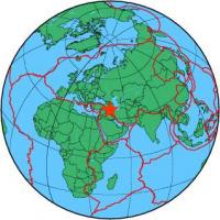
| Region | IRAN-IRAQ BORDER REGION |
| Date time | 2013-02-25 08:03:13.2 UTC |
| Location | 36.994 ; 45.257 |
| Depth | 2 km |
| Distance | 49 km WNW of Mahābād, Iran / pop: 162,000 / local time: 11:33:13.2 2013-02-25 12 km W of Naqadeh, Iran / pop: 73,500 / local time: 11:33:13.2 2013-02-25 |
All data providers for this event:
Montenegro Seismological Observatory -- Podgorica, Montenegro (MSO)GeoForschungsZentrum (GFZ) -- Potsdam, Germany (GFZ)
Republican Seismic Survey Center or Azerbaijan National Academy of Sciences -- Baku, Azerbaijan (RSSC)
Geophysical Survey of the Russian Academy of Sciences -- Obninsk, Russia (GSRAS)
Iraqi Meteorological Organisation and Seismology, Seismological Department -- Baghdad, Iraq (ISN)
Kandilli Observatory and Earthquake Research Institute -- Istanbul, Türkiye (KOERI)
National Earthquake Information Center, U.S. Geological Survey -- Golden, United States (NEIC)
Disaster and Emergency Management Presidency, Earthquake Department (AFAD) -- Ankara, Türkiye (AFAD)
Institute of Geophysics, University of Tehran -- Tehran, Iran (IGUT)
Further information can be found at:
Geophysical Survey of the Russian Academy of Sciences -- Obninsk, Russia (GSRAS)Institute of Geophysics, University of Tehran -- Tehran, Iran (IGUT)
International Institute for Earthquake Engineering and Seismology -- Tehran, Iran (IIEES)