| Magnitude | 6.1 |
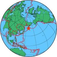
| Region | OFF EAST COAST OF KAMCHATKA |
| Date time | 2013-05-21 05:43:21.1 UTC |
| Location | 52.336 ; 160.011 |
| Depth | 30 km |
| Distance | 1600 km E of Komsomolsk-on-Amur, Russia / pop: 275,000 / local time: 16:43:21.1 2013-05-21 123 km ESE of Petropavlovsk-Kamchatsky, Russia / pop: 187,000 / local time: 17:43:21.1 2013-05-21 |
All data providers for this event:
National Earthquake Information Center, U.S. Geological Survey -- Golden, United States (NEIC)GeoSphere Austria -- Vienna, Austria (GSA)
Seismological Institute of Kosovo/UNMIK -- Pristina, Kosovo/UNMIK (SIK)
Landsamt fur Geologie, Rohstoffe und Bergbau -- Freiburg, Germany (LED)
Instituto Geografico Nacional -- Madrid, Spain (IGN)
National Institute for Earth Physics -- Bucharest, Romania (NIEP)
Institute of Geophysics of the Czech Academy of Sciences -- Prague, Czech Republic (GFU)
Laboratoire de Detection et de Geophysique -- Bruyeres-le-Chatel, France (LDG)
Montenegro Seismological Observatory -- Podgorica, Montenegro (MSO)
GeoForschungsZentrum (GFZ) -- Potsdam, Germany (GFZ)
The research institute NORSAR -- Kjeller, Norway (NORSAR)
Republican Seismic Survey Center or Azerbaijan National Academy of Sciences -- Baku, Azerbaijan (RSSC)
Geophysical Survey of the Russian Academy of Sciences -- Obninsk, Russia (GSRAS)
Further information can be found at:
Geophysical Survey of the Russian Academy of Sciences -- Obninsk, Russia (GSRAS)National Earthquake Information Center, U.S. Geological Survey -- Golden, United States (NEIC)
GeoForschungsZentrum (GFZ) -- Potsdam, Germany (GFZ)