| Magnitude | 4.2 |
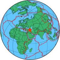
| Region | TURKEY-IRAN BORDER REGION |
| Date time | 2013-06-28 21:16:22.6 UTC |
| Location | 38.596 ; 44.777 |
| Depth | 10 km |
| Distance | 119 km NNW of Orūmīyeh, Iran / pop: 577,000 / local time: 01:46:22.6 2013-06-29 16 km W of Khowy, Iran / pop: 175,000 / local time: 01:46:22.6 2013-06-29 |
All data providers for this event:
GeoForschungsZentrum (GFZ) -- Potsdam, Germany (GFZ)Republican Seismic Survey Center or Azerbaijan National Academy of Sciences -- Baku, Azerbaijan (RSSC)
Geophysical Survey of the Russian Academy of Sciences -- Obninsk, Russia (GSRAS)
Kandilli Observatory and Earthquake Research Institute -- Istanbul, Türkiye (KOERI)
National Earthquake Information Center, U.S. Geological Survey -- Golden, United States (NEIC)
Disaster and Emergency Management Presidency, Earthquake Department (AFAD) -- Ankara, Türkiye (AFAD)
Institute of Geophysics, University of Tehran -- Tehran, Iran (IGUT)
Further information can be found at:
Kandilli Observatory and Earthquake Research Institute -- Istanbul, Türkiye (KOERI)Disaster and Emergency Management Presidency, Earthquake Department (AFAD) -- Ankara, Türkiye (AFAD)
Geophysical Survey of the Russian Academy of Sciences -- Obninsk, Russia (GSRAS)
International Institute for Earthquake Engineering and Seismology -- Tehran, Iran (IIEES)
Institute of Geophysics, University of Tehran -- Tehran, Iran (IGUT)