| Magnitude | 6.4 |
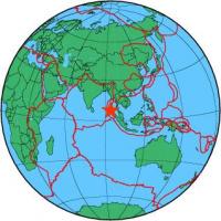
| Region | NICOBAR ISLANDS, INDIA REGION |
| Date time | 2014-03-21 13:41:08.0 UTC |
| Location | 7.692 ; 94.199 |
| Depth | 10 km |
| Distance | 270 km NW of Banda Aceh, Indonesia / pop: 250,000 / local time: 20:41:08.0 2014-03-21 235 km NW of Sabang, Indonesia / pop: 24,500 / local time: 20:41:08.0 2014-03-21 |
All data providers for this event:
Geophysical Survey of the Russian Academy of Sciences -- Obninsk, Russia (GSRAS)Kandilli Observatory and Earthquake Research Institute -- Istanbul, Türkiye (KOERI)
Bundesanstalt fur Geowissenschaften und Rohstoffe, German Regional Seismograph Network -- Hannover, Germany (BGR)
National Earthquake Information Center, U.S. Geological Survey -- Golden, United States (NEIC)
GeoSphere Austria -- Vienna, Austria (GSA)
Landsamt fur Geologie, Rohstoffe und Bergbau -- Freiburg, Germany (LED)
National Institute for Earth Physics -- Bucharest, Romania (NIEP)
Institute of Geophysics of the Czech Academy of Sciences -- Prague, Czech Republic (GFU)
Seismological Survey of Serbia -- Belgrade, Serbia (BEO)
Montenegro Seismological Observatory -- Podgorica, Montenegro (MSO)
GeoForschungsZentrum (GFZ) -- Potsdam, Germany (GFZ)
The research institute NORSAR -- Kjeller, Norway (NORSAR)
Malta Seismic Network, Seismic Monitoring and Research Unit (SMRU), University of Malta -- Imsida, Malta (MLT)
Further information can be found at:
Badan Meteorologi, Klimatologi dan Geofisika -- Jakarta, Indonesia (BMKG)National Earthquake Information Center, U.S. Geological Survey -- Golden, United States (NEIC)
GeoForschungsZentrum (GFZ) -- Potsdam, Germany (GFZ)