| Magnitude | 6.3 |
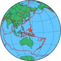
| Region | STATE OF YAP, MICRONESIA |
| Date time | 2014-05-15 08:16:36.7 UTC |
| Location | 6.365 ; 144.866 |
| Depth | 10 km |
| Distance | 989 km S of Saipan, Northern Mariana Islands / pop: 48,200 / local time: 18:16:36.7 2014-05-15 777 km SSE of Talofofo Village, Guam / pop: 3,200 / local time: 18:16:36.7 2014-05-15 |
All data providers for this event:
Instituto Geografico Nacional -- Madrid, Spain (IGN)Japan Meteorological Agency Seismic Network -- Tokyo, Japan (JMA)
GeoForschungsZentrum (GFZ) -- Potsdam, Germany (GFZ)
HUN-REN EPSS Kövesligethy Radó Seismological Observato -- Budapest, Hungary (BUD)
Pacific Tsunami Warning Seismic System, Pacific Tsunami Warning Center, Ewa Beach, Hawaii -- Ewa Beach, United States (PT)
Geophysical Survey of the Russian Academy of Sciences -- Obninsk, Russia (GSRAS)
Kandilli Observatory and Earthquake Research Institute -- Istanbul, Türkiye (KOERI)
Instituto Nazionale di Geofisica e Vulcanologia -- Rome, Italy (INGV) -- DOI: https://terremoti.ingv.it/en/iside
National Earthquake Information Center, U.S. Geological Survey -- Golden, United States (NEIC)
Pacific Tsunami Warning Center -- Honolulu, United States (PTWC)
Further information can be found at:
National Earthquake Information Center, U.S. Geological Survey -- Golden, United States (NEIC)Badan Meteorologi, Klimatologi dan Geofisika -- Jakarta, Indonesia (BMKG)
GeoForschungsZentrum (GFZ) -- Potsdam, Germany (GFZ)