| Magnitude | 4.7 |
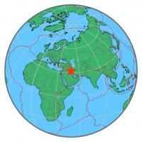
| Region | IRAN-IRAQ BORDER REGION |
| Date time | 2014-10-15 22:31:42.1 UTC |
| Location | 32.412 ; 47.974 |
| Depth | 10 km |
| Distance | 101 km NE of Al ‘Amārah, Iraq / pop: 323,000 / local time: 01:31:42.1 2014-10-16 35 km WNW of Shūsh, Iran / pop: 52,200 / local time: 02:01:42.1 2014-10-16 |
All data providers for this event:
National Institute for Earth Physics -- Bucharest, Romania (NIEP)Laboratoire de Detection et de Geophysique -- Bruyeres-le-Chatel, France (LDG)
GeoForschungsZentrum (GFZ) -- Potsdam, Germany (GFZ)
Montenegro Seismological Observatory -- Podgorica, Montenegro (MSO)
HUN-REN EPSS Kövesligethy Radó Seismological Observato -- Budapest, Hungary (BUD)
Geophysical Survey of the Russian Academy of Sciences -- Obninsk, Russia (GSRAS)
Kandilli Observatory and Earthquake Research Institute -- Istanbul, Türkiye (KOERI)
National Earthquake Information Center, U.S. Geological Survey -- Golden, United States (NEIC)
Institute of Geophysics, University of Tehran -- Tehran, Iran (IGUT)
Further information can be found at:
Institute of Geophysics, University of Tehran -- Tehran, Iran (IGUT)International Institute for Earthquake Engineering and Seismology -- Tehran, Iran (IIEES)
Geophysical Survey of the Russian Academy of Sciences -- Obninsk, Russia (GSRAS)