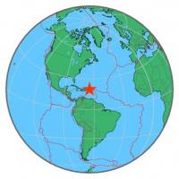
| Magnitude | 4.8 |
| Region | VIRGIN ISLANDS REGION |
| Date time | 2015-07-16 17:38:00.9 UTC |
| Location | 19.595 ; -64.579 |
| Depth | 15 km |
| Distance | 144 km N of Charlotte Amalie, U.S. Virgin Islands / pop: 20,000 / local time: 13:38:00.9 2015-07-16 130 km N of Road Town, British Virgin Islands / pop: 8,400 / local time: 13:38:00.9 2015-07-16 |
All data providers for this event:
Laboratoire de Detection et de Geophysique -- Bruyeres-le-Chatel, France (LDG)Inst. de Astron., Geof. e Ciencias Atmos., Univ. de S?o Paulo, Brazil -- , Brazil (VAO)
Alaska Tsunami Warning Seismic System, West Coast and Alaska Tsunami Warning Center -- Anchorage, United States (AT)
Puerto Rico Seismic Network (PRSN) and Puerto Rico Strong Motion Program (PRSMP), University of Puerto Rico at Mayaguez -- Mayagueez, Puerto Rico (PR)
National Earthquake Information Center, U.S. Geological Survey -- Golden, United States (NEIC)
Further information can be found at:
GeoForschungsZentrum (GFZ) -- Potsdam, Germany (GFZ)National Earthquake Information Center, U.S. Geological Survey -- Golden, United States (NEIC)