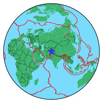
| Magnitude | 5.3 |
| Region | HINDU KUSH REGION, AFGHANISTAN |
| Date time | 2016-02-21 09:12:07.7 UTC |
| Location | 36.552 ; 70.962 |
| Depth | 173 km |
| Distance | 189 km E of Kunduz, Afghanistan / pop: 161,000 / local time: 13:42:07.7 2016-02-21 37 km SSE of Jurm, Afghanistan / pop: 12,100 / local time: 13:42:07.7 2016-02-21 |
All data providers for this event:
National Institute for Earth Physics -- Bucharest, Romania (NIEP)Laboratoire de Detection et de Geophysique -- Bruyeres-le-Chatel, France (LDG)
GeoForschungsZentrum (GFZ) -- Potsdam, Germany (GFZ)
Inst. de Astron., Geof. e Ciencias Atmos., Univ. de S?o Paulo, Brazil -- , Brazil (VAO)
HUN-REN EPSS Kövesligethy Radó Seismological Observato -- Budapest, Hungary (BUD)
Republican Seismic Survey Center or Azerbaijan National Academy of Sciences -- Baku, Azerbaijan (RSSC)
Geophysical Survey of the Russian Academy of Sciences -- Obninsk, Russia (GSRAS)
Kandilli Observatory and Earthquake Research Institute -- Istanbul, Türkiye (KOERI)
National Earthquake Information Center, U.S. Geological Survey -- Golden, United States (NEIC)
Kazakhstan National Data Center -- Almaty, Kazakhstan (KNDC)
Further information can be found at:
Geophysical Survey of the Russian Academy of Sciences -- Obninsk, Russia (GSRAS)GeoForschungsZentrum (GFZ) -- Potsdam, Germany (GFZ)
National Earthquake Information Center, U.S. Geological Survey -- Golden, United States (NEIC)