| Magnitude | 5.3 |
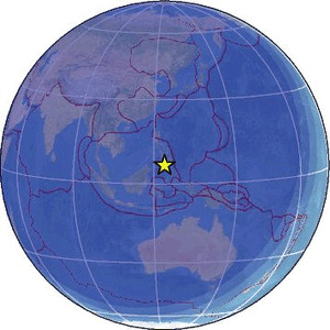
| Region | MORO GULF, MINDANAO, PHILIPPINES |
| Date time | 2026-01-27 17:05:10.2 UTC |
| Location | 6.464 ; 123.799 |
| Depth | 10 km |
| Distance | 98 km SSW of Cotabato, Philippines / pop: 179,000 / local time: 01:05:10.2 2026-01-28 30 km WSW of Kalamansig, Philippines / pop: 12,800 / local time: 01:05:10.2 2026-01-28 |
Source parameters reviewed by a seismologist
All data providers for this event:
Geoscience Australia, Canberra, ACT, Australia -- Canberra, Australia (AUST)Badan Meteorologi, Klimatologi dan Geofisika -- Jakarta, Indonesia (BMKG)
GeoForschungsZentrum (GFZ) -- Potsdam, Germany (GFZ)
Geophysical Survey of the Russian Academy of Sciences -- Obninsk, Russia (GSRAS)
Instituto Nazionale di Geofisica e Vulcanologia -- Rome, Italy (INGV) -- DOI: https://terremoti.ingv.it/en/iside
Kandilli Observatory and Earthquake Research Institute -- Istanbul, Türkiye (KOERI)
Ukrainian NDC, Main Center of Special Monitoring -- Kyiv, Ukraine (MCSM)
Malaysian Meteorological Department -- Kuala Lumpur, Malaysia (MET)
National Earthquake Information Center, U.S. Geological Survey -- Golden, United States (NEIC)
Philippine Inst. of Volcanology and Seismology, Quezon City, Philippines -- Manila, Philippines (PIVS)
Republican Seismic Survey Center or Azerbaijan National Academy of Sciences -- Baku, Azerbaijan (RSSC)
EMSC -- Arpajon, France (SC4)
Further information can be found at:
GeoForschungsZentrum (GFZ) -- Potsdam, Germany (GFZ)National Earthquake Information Center, U.S. Geological Survey -- Golden, United States (NEIC)
Philippine Inst. of Volcanology and Seismology, Quezon City, Philippines -- Manila, Philippines (PIVS)
Badan Meteorologi, Klimatologi dan Geofisika -- Jakarta, Indonesia (BMKG)