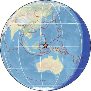
| Magnitude | 5.2 |
| Region | MOLUCCA SEA |
| Date time | 2026-04-13 06:23:23.0 UTC |
| Location | 1.033 ; 126.600 |
| Depth | 55 km |
| Distance | 201 km E of Manado, Indonesia / pop: 451,000 / local time: 14:23:23.0 2026-04-13 91 km W of Ternate, Indonesia / pop: 101,000 / local time: 15:23:23.0 2026-04-13 |
Source parameters reviewed by a seismologist
All data providers for this event:
Geoscience Australia, Canberra, ACT, Australia -- Canberra, Australia (AUST)Badan Meteorologi, Klimatologi dan Geofisika -- Jakarta, Indonesia (BMKG)
GeoForschungsZentrum (GFZ) -- Potsdam, Germany (GFZ)
Malaysian Meteorological Department -- Kuala Lumpur, Malaysia (MET)
National Earthquake Information Center, U.S. Geological Survey -- Golden, United States (NEIC)
EMSC -- Arpajon, France (SC4)
Further information can be found at:
National Earthquake Information Center, U.S. Geological Survey -- Golden, United States (NEIC)Philippine Inst. of Volcanology and Seismology, Quezon City, Philippines -- Manila, Philippines (PIVS)
Badan Meteorologi, Klimatologi dan Geofisika -- Jakarta, Indonesia (BMKG)
GeoForschungsZentrum (GFZ) -- Potsdam, Germany (GFZ)