| Magnitude | 5.0 |
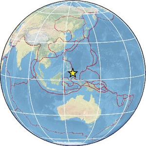
| Region | PHILIPPINE ISLANDS REGION |
| Date time | 2026-06-17 03:46:15.9 UTC |
| Location | 5.563 ; 127.282 |
| Depth | 35 km |
| Distance | 195 km SE of Mati, Philippines / pop: 105,000 / local time: 11:46:15.9 2026-06-17 151 km ESE of Pondaguitan, Philippines / pop: 2,100 / local time: 11:46:15.9 2026-06-17 |
Source parameters reviewed by a seismologist
All data providers for this event:
Badan Meteorologi, Klimatologi dan Geofisika -- Jakarta, Indonesia (BMKG)Geophysical Survey of the Russian Academy of Sciences -- Obninsk, Russia (GSRAS)
Ukrainian NDC, Main Center of Special Monitoring -- Kyiv, Ukraine (MCSM)
National Earthquake Information Center, U.S. Geological Survey -- Golden, United States (NEIC)
Republican Seismic Survey Center or Azerbaijan National Academy of Sciences -- Baku, Azerbaijan (RSSC)
EMSC -- Arpajon, France (SC4)
Further information can be found at:
National Earthquake Information Center, U.S. Geological Survey -- Golden, United States (NEIC)Philippine Inst. of Volcanology and Seismology, Quezon City, Philippines -- Manila, Philippines (PIVS)
Badan Meteorologi, Klimatologi dan Geofisika -- Jakarta, Indonesia (BMKG)
GeoForschungsZentrum (GFZ) -- Potsdam, Germany (GFZ)